Canberra to Nowra, May
It's late autumn and I'm looking for a break from solid triathlon and duathlon training & racing for the past 7 months. I'm not working and looking forward to relaxation in the bush. My nephew, Warren, lives in Nowra and has invited me to stay with him for a couple of days. I have a cousin living at Shoalhaven Heads, a few km away, whom I also plan to visit.
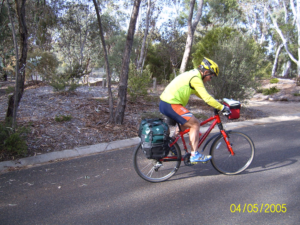
This will be my first cycle tour on my 4 year old Cannondale F600 mountain bike. My bike set-up is:
- slick tyres
- Ortlieb handle bar pannier (new)
- Topeak rear rack (new)
- Ortlieb rear panniers
- 720i Polar Heart Rate Monitor
The bike with racks weighs 12kg, and the 3 panniers, with all my gear, but not including food or water, weighs 12kg also.
The forecast for the 240k forward journey is fine, cool weather, with cold nights and warm days. The roads are a mix of sealed and gravel, with primarily local farm traffic.Wednesday 4 May: Canberra, Captains Flat, Braidwood - 116km
Left home in Cook, a suburb in north western Canberra, at 9am. My wife, Carolyne, farewelled me, taking photos as I headed off in fine, cold conditions, ideal for cycling.
Followed cycle paths across Canberra, past Lake Burly Griffin, to Queanbeyan. Mainly flat. Skirted the CBD and headed west on the Kings Highway towards Bungendore. After a couple of kilometres, turned right towards Captains Flat. The traffic was quite heavy, with lots of trucks, both small and large. For the first few kilometres there were steady climbs, with no cycling shoulder on the road. Passed many hobby farms and the traffic steadily lessened.
About 15km out of Queanbeyan the road emerged into a wide, shallow valley, and the traffic was a comfortably low level. This was pleasant, relaxed cycle touring.
Coming around a bend in the road, saw a scrawny, small red fox on the edge of the road. It didn't hear me until I was only a metre or two away, by which time I had a good view of it. It trotted away along the ride behind me. The drought-affected countryside would have provided little prey for it.
Saw an echidna strolling a couple metres from the road. For the 2o kilometres leading to Captains Flat the road was accompanied by the unused railway line from Queanbeyan to Captains Flat. Every 40m beside the grass covered but otherwise solid looking track there was a power line of rail steel, with 2 white insulators perched on top. The power lines had long gone.
The road climbed gently into Captains Flat and I took a turn-off to the old mine. From the mine site, with lots of rusting metal, there was a panoramic view of the small town nestled in the valley below. I rode down a gravel road to the main street with a pub, a coffee shop not open during the week, and a nice public park.
The only people in evidence anywhere were a couple of mothers sitting at a pincnic table and their young offspring frollicking nearby. There were public toilets and a water tap, with a large hose attached, and a sign saying that the water was for the use of residents during the drought. I filled both my water bottles and headed east on the road towards Braidwood.
The sealed road rose steeply and, after a kilometre or so, turned to gravel. I continued to climb, passing through heavily wooded countryside and into Tallaganda State Forest. With slick tyres and soft gravel, the bike slid over a couple of times, but as I was travelling slowly I didn't come to grief. At the top of the climb, the highest point for the day, I stopped to eat the 2 sandwiches I had carried from home. There was only the occasional 4WD vehicle to share the road with me.
The descent down the mountain range was pleasant, with the gravel surface generally well made. The forest slowly cleared to reveal the wide Shoalhaven River valley. At the bottom of the valley I turned left onto the Kawarree Road that links Braidwood with Cooma. The road was wide and sealed, and still the traffic was light.
I crossed the river and saw a gravel road to the right heading through Majors Creek and Araluen to the coast. I continued straight ahead towards Braidwood. The countryside was delightful farm country, greener than on the western side of the mountains. The road followed the river until the last few kilometres into Braidwood. Was forced to stop as a large mob of cattle was being herded along the road towards me by a bloke on horseback and his five dogs. The cattle were very wary of me, in my bright lycra, helmet and sunnies.
For the last 5-6 km rode over several hills and the into Braidwood, an old, well-preserved town. School children were out playing on their way home, and the traffic was quite heavy. The town lies on the Kings Highway joining Canberra and Queanbeyan with the coast.
There are two hotels in town, and I started at the Royal Mail Hotel, on a corner in the centre of town. I asked for a quiet room and was given room 15, with two single beds, the last room in the corridor at the back, for $30. This suited me fine.
I showered and went to explore the town. The community-run internet cafe, although open till 6pm, was little use as the operator was experiencing trouble with the server. After checking out all the eateries, I returned to the Royal Mail to enjoy several schooners of "Old". Although friendly, the pub was noisy with about 10 TV sets flickering above the shelves of bottles behind the bar. I wandered along the street to the friendly and convivial Braidwood Eureka Pizzeria, where I ate a terrific large, Greek pizza for $26.
My hotel room was lit with a single, weak globe strung on the high ceiling. With nothing to keep me up I hit the sack at the ridiculous time of 7:30pm.
Day's stats:
- Averaged 20.6kph
- Started at 650m altitude, reached a high of 1,160m
- Total ascent, 1,380m.
Thursday 5 May: Braidwood, Nerriga, Nowra - 121km
After a good night's sleep arose before 6am. Showered, wandered along the street in the pre-dawn light to the bakery where I drank a weak coffee. Was surprised that the bakery opened so early, and was amazed at the constant stream of people coming in for coffee, pies and croissants. Spoke to Carolyne on my mobile and photographed the street scape in the pink light. Bought 6 multigrain rolls, in anticipation that there would be little if any food to purchase along the way. Ate my muesli in my hotel room, packed my bike and left the Royal Mail at 7:30am. It was cold and fine.
Headed north on the road to Queanbeyan for a few hundred metres before turning onto the much quieter north-easterly road to Nerriga and Nowra. The undulating road passed through pleasant farm country , a few kilometres to the east of the Shoalhaven River. School buses, farm utes and 4WDs were heading back to Braidwood and Qeanbeyan.
To my surprise the road turned to gravel - had thought it was sealed to Nerriga. The road climbed through wooded country and was difficult going at times, with fine, sandy gravel that was badly corrugated. Now regretted having slick tyres and resolved not to ride with them again on such a surface. Realised that I was travelling more slowly than expected and became a little concerned about reaching Nowra in comfortable time. Eventually the gravel road gave way to a sealed section leading into the small village of Nerriga.
It was now late morning. The main street comprised just a few buildings, including a small, single story pub that displayed an Open sign but with no sign of patrons. A large yellow Shell sign had no obvious petrol bowsers nearby. There was a tiny unpainted timber building with a sign saying it was a former butchery. Another building had no usual indication that it was a shop, but had sandwich boards advertising special hambugers. The woman served me a ginger beer and advised that quite a few cyclists passed through. Most have support vehicles or camp about 4km past the village, beside the river.
Immediately outside the village the gravel returned and the road descended to a bridge across the river, a tributary to the Shoalhaven. On the far side of the river the road was sealed for a kilometres or so as it climbed very steeply through thick forest. With the return of the gravel the road continued to climb for another two or three kilometres, past dramatic rocks towering over the road way. Stopped to take off warm clothing, to take a photo and recover. I was now in Morton National Park.
Over the crest of the mountain, at about 70km, the descent was gradual and continued, interrupted by flat sections and small climbs, for about 40km. The road surface was difficult to negotiate, with almost continual corrugations and fine bull dust several centimetres thick. My front wheel was frequently caught in drifts that forced me to stop. Had to concentrate hard on maintaining my momentum and finding the best route through the corrugations, pot-holes and mounds of dust. The going was slow - was averaging maybe 10-12 kph at this stage. Vehicles coming the opposite directions left clouds of dust that took several minutes to settle.
At about 1pm stopped to eat my bread rolls, only to be covered in dust as about eight vehicles passed in the 15 minutes that I was stopped. Was already feeling tired - in retrospect I should have eaten more and earlier. Sassafras is marked as a settlement on the map but proved to be only several farm houses in a break in the national park. An old lady, standing beside her 4WD, said that from a distance she thought I was one of her cows that had got through the fence! She told me that she was a third generation resident of her property, and pointed to a farm house near the road that she said her grandfather built in 1908.
After leaving the national park the countryside was boring: low, scrubby growth in the rocky soil. The whole time was expecting the descent to become steep and windy - thank goodness it remained gradual. Came across council workers who were laying fresh gravel, and from there the cycling was a lot easier. Felt more tired than expected, no doubt a result of the concentration and physical effort required to make reasonable progress.
Was relieved when I reached a division in the road, with the left fork, that I followed, continuing to Nowra and the right fork going directly to the Princes Highway. The quality of the road surface did not improve but there was now no other traffic. Eventually I could see HMAS Albatross Air Station ahead, and several kilometres further I reached a wide, sealed and new road that took me past the air station. The road was now busy but there was a cycle lane on the shoulder. A young bloke on a mountain bike overtook me, but even though tired I was able to hang on to him.
Shortly arrived at the turn-off to my nephew, Warren's, home that I reached at 3:30pm, relieved and very tired. Was pleased that I did not have to ride again the next day. I stayed with Warren for three nights.
Day's stats:
- Averaged 19.8kph
- Started at 690m altitude, reached a high of 830m
- Total ascent, 1,060m.
Sunday 8 May: Nowra, Kangaroo Valley, Bundanoon, Marulan, Bungonia, Goulburn - 146km
Left Warren's house refreshed at 8am, reminding him to call his mother for Mothers Day. Traversed Nowra in the early Sunday morning traffic. Crossed over the Shoalhaven River for the last time on the new span of the bridge (the older one is a striking metal structure was built in 1881) heading north.
The weather was delightful: a cloudless sky, still and 11°C. On the northern oustkirts of Nowra turned north-west on the road to Kangaroo Valley. After a couple of kilometres I started up Cambewarra Mountain, the first of two major climbs for the day. Stopped to take off my warm clothing. The traffic was light and the bush full of calls from kookaburras, whip birds and black cockatoos. The climb was long but through lush bush, with an occasional farm where the ground was not too steep. I felt comfortable, and there few trucks.
Over the crest and relaxed for the steep descent into Kangaroo Valley. The valley was blanketted in thick fog and I soon became cold. Stopped to put my warm gear on again. At bottom of the descent, there were wombat droppings every metre along the gutter for a couple of hundred metres.
In the village of Kangaroo Valley there were already many tourists to make the most of the shops selling trinkets, art and take away food. Crossed the old bridge and stopped at the service station to top up my water bottle. The countryside was undulationg until I hit the second climb, up Barrengarry Mountain. This was longer than Cambewarra, but there was room for me and the steady traffic. Stopped to take a photo across the white fog. Near the summit the road briefly narrowed, leaving little room for cars to pass me. There were a couple of false summits, but I soon crossed the Fitzroy Canal and knew that the last of the steep climbing was behind me.
At Fitzroy Falls stopped for a breather and to eat an apple. Found there was no mobile phone signal. The countyrside now was undulationg green, farm country, the road lined with large gums. Passed Sheepwash Road, the main road connecting Nowra and Kangaroo Valley with Moss Vale and Sydney. The traffic lessened, and continued to lessen as I passed other turn-offs to Sydney. The cycling was very pleasant, with a mild temperature, little wind and scattered clouds.
At Mount Broughton Road I turned left towards Exeter. After starting the day northwards, I had steadily turned westwards, and now was heading in a south-westerly direction. After passing through the village of Exeter, the only traffic was local. The next town was Bundanoon, a delightful place and a favourite of mine. There are several cafes and other eateries, and all were well patronised with Sunday drivers from Sydney and elsewhere.
Stopped at a cafe and drank a coffee on the small verandah in the sunshine, with my bike leaning against the steps. Bought bread rolls from a bakery and ate those at the cafe. A middle-aged couple interrupted me to ask where I'd ridden from. When I told them "From Nowra" they announced they had overtaken me twice up the two mountains climbs, and were most surprised that I had reached Bundanoon only a few minutes after them.
After a 35 minute break I continued through the villages of Penrose, Wingello and Tallong. This was one of the pleasantest parts of the journey, with lots of forest, occasional farms, little traffic and a beautiful autumn afternoon. Reached the village of Marulan on the Hume Highway at 3pm. Had to decide whether to stay at the samll pub there, or continue to Goulburn through the settlement of Bungonia, south of Marulan. Did not have a map of this section, and my enquiries of a couple of locals didn't help much.
As Marulan did not look inviting and I still felt strong, decided to risk the ride via Bungonia. Followed the Hume Highway for a a couple of kilometres, with heavy traffic thundering beside me. The cycle lane was wide and did not feel threatened. Was pleased to turn south on the quiet, small, unlined road that passed through a mix of bush and small farms. Realised that I was gradually descending, and guessed that there would be consequesnt climbing to Goulburn. The cycl;ing was pleasant and easy.
At the settlement of Bungonia turned west and immediately started to climb. For an hour I climbed over one hill after another, directly towards the setting sun - it was not steep but I started to feel very tired. For most of the time the road passed through forest, with roos hopping across and lots of birds calling. Finally I rode over a crest, at 810m the highest point of the day, and could see the communication towers on the hills around Goulburn. The road descended into open country and I was confident that would reach Gouburn in the light, though with little to spare. For last ten kilometres was thinking only of the beers and dinner to come!
Arrived in Goulburn at 5pm, just as the sun was setting. At the outskirts of town a sign announced that the city was on level 5 water restrictions.
The first hotel I came across, the Coolavin Hotel, charged $25 a single. Was given a single bed in a large room. The staff at the hotel advised that, as there was no counter dinner available, I should try the Railway Bowls Club. Took the advice, but found it the food to be ordinary and lots of smokers and families celebrating Mothers Day. Enjoyed 4 schooners of 'Old' for $3 each. Large rump steak & vegetables for $13, plus Diane sauce for 50c, with a side plate of potato wedges with sour cream and sweet chilli sauce for 44.50.
Once again hit the sack early, about 8:30pm.
Day's stats:
- Averaged 19.9kph
- Started at 12m altitude , reaching a high of 809m
- Total ascent 2,115m.
Monday 9 May: Goulburn, Tarago, Bungendore, Canberra - 108km
Awoke early to a clear, fine and cold day. Showered, ate meusli in my room and at 7:45am left the Coolavin Hotel to seek out an ATM in the main street. The sky was clear, the air was still, and it was very cold, about 0°C.
Left the city heading south, towards Tarago. It was an excellent road for cycling: wide, with shoulders, and light traffic. The countryside was gently undulating, with large grazing properties for sheep, cattle and alpaca. Parralel to the road to the west was a line of low hills .
Soon realised that the back of my legs were tight from the yesterday's ride, and had to stop to stretch regularly. Passed through the settlement of Lake Bathurst, with some old farm houses, a B&B and a tea house that is open only at weekends.
The railway line to Canberra followed the road to the west. The only traffic on it was a track-monitoring vehicle travelling at a modest pace on a steel wheel base.
Reached the village Tarago at about 10am and turned right on the road to Bungendore. Despite many residences the village was deadly quiet. The road climbed up a long hill, and continued through hilly, undulating country for 30 kms. The country was more heavily wooded, with fewer farms.
Descended a long hill and could see the solid line of hills to the west that bordered Lake George. After another 3-4 kms arrived at Bungendore about 11:30am. It used to be no more than a village, but people have moved here for the country lifestyle and commute to Canberra and Queanbeyan to work. I passed a large suburban-like development on the northern side of town. Stopped in the main street at a cafe for a quiche and salad, a ginger beer and a coffee in the sun. Brought several bread rolls from the bakery across the road, and ate those while finishing off the coffee.
After a good break, headed towards Smith's Gap that I could see several kilometres away in the line of hills to the west. The climb was steep but continued for only a kilometre or so. Then up and down through hobby farms and small wineries for 25km before reaching the Federal Highway, with only 20km to Canberra.
Called Carolyne and arranged to meet her for coffee at Tilleys Cafe in the northern suburb of Lyneham. Arrived about 2:20pm: it was a very pleasant way to finish the journey.
Day's stats:
- Averaged 20.4kph
- Started at 667m altitude, high of 899m
- Total ascent of 840m.
posted by Bob at 9:48 am
![]()
![]()

3 Comments:
Great read!! I look forward to reading more of your amazing adventures in the future!
Hi bob
Enjoyed the commentary. My family and I are doing a similar route in September 09 leaving wollongong but were considering doing it clock wise. Having ridden it, do you think it with the dirt in mind, would it in your opinion be better either way?
Cheers Norm
nice definition here they are giving.. well explained.. Awesome weekend, Thanks for the riding guys. It'll be cool to see more riders there next year too.
Bikes Canberra
Post a Comment
<< Home